The road seems to slice straight through the water on a misty autumn morning in Lelystad. Your GPS calmly insists you’re driving across a lake, yet outside the window there are cows grazing, wind turbines spinning, a primary school, and a neighborhood grocery store. The sky hangs low, the land is perfectly flat, and everything feels ordinary. It’s easy to forget that older maps once showed this entire stretch as open water.
A Dutch engineer once told me with a smile, “We don’t fight the sea. We negotiate with it.” Standing there, you realize he wasn’t exaggerating. It’s an ongoing agreement, constantly revised.
How a Flooded Delta Learned to Redraw Its Own Lines
Look at a satellite image of the Netherlands and you’ll notice a web of rivers threading through the land. Then something unusual appears. Some rivers turn sharply at right angles. Others end in artificial lakes or disappear behind ruler-straight dikes. It doesn’t look accidental.

For centuries, the Netherlands has been a quiet, continuous construction site. Take the Rhine. As it enters Dutch territory, it splits into branches — the Waal, IJssel, and Nederrijn — twisting and renaming itself. On paper, it looks chaotic. On the ground, it’s intentional. Engineers have redirected, split, and regulated these channels for nearly 800 years, carefully balancing shipping routes, flood safety, and farmland protection.
During the 18th and 19th centuries, regulators, weirs, and canal projects transformed a wild delta into a managed hydraulic system. Rivers no longer wander freely. They are guided with purpose.
The logic behind this is straightforward. The Netherlands sits in a low delta where major European rivers empty into a narrow coastal strip. Without intervention, those rivers would flood and reshape the land unpredictably. Here, even a small shift in a river’s path could mean a drowned village or ruined harvest.
So the Dutch began drawing new lines: straightened channels to speed water to the sea, overflow basins to absorb excess flow, and dikes to contain pressure. The map became less a reflection of nature and more a record of deliberate decisions, etched into clay, sand, and concrete.
Reclaiming Land from the Sea, One Polder at a Time
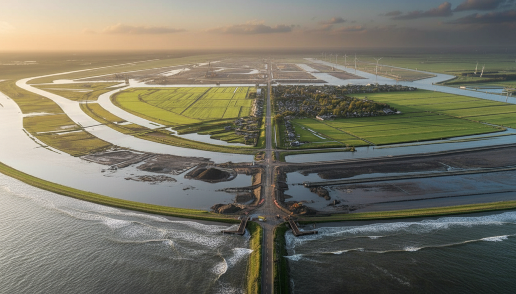
If controlling rivers was about survival, reclaiming land was about ambition. A “polder” is land that used to be underwater but is now enclosed by dikes and kept dry with pumps. The word sounds technical. The reality feels bold.
The method was deceptively simple: build a circular dike, pump out the water, and allow the exposed seabed to dry and solidify. Eventually, new land emerged — often lying below surrounding water levels. Farms appeared. Houses followed. Entire communities grew on what had once been open sea.
The transformation of the Zuiderzee marked a turning point. Before the 20th century, this vast bay cut deep into the country, allowing North Sea storms to surge inland. After a devastating flood in 1916, the Netherlands launched an unprecedented project. In 1932, the 32-kilometer Afsluitdijk sealed off the bay from the sea.
Gradually, the saltwater turned into the freshwater IJsselmeer. New polders followed: Wieringermeer, Noordoostpolder, and eventually Flevoland. Cities like Lelystad and Almere now stand where waves once rolled. Flevoland itself became an entirely new province, engineered from sand and clay in the 20th century.
What feels remarkable is the calm confidence behind it. The Dutch didn’t merely raise defenses. They redesigned coastlines, converted seas into lakes, and reimagined geography itself — all guided by detailed elevation studies, soil analysis, and long-term water strategies.
From Defending Against Water to Designing With It
For much of its history, the Dutch strategy was clear: keep water out at any cost. Higher dikes. Stronger barriers. Clear boundaries between land and sea. For decades, that approach delivered safety.
But rising sea levels, heavier rainfall, and stronger storms forced a rethink. Over the last thirty years, a new philosophy has emerged one that feels almost counterintuitive: give water more room instead of less.

The “Room for the River” program embodies this shift. Instead of endlessly reinforcing dikes, engineers lowered floodplains, created side channels, moved levees inland, and in some cases relocated homes. When rivers swell, the water now has space to spread safely instead of crashing into rigid walls.
The transition wasn’t painless. Giving up farmland or homes for floodplains is emotionally difficult, even if models show it’s safer long term. Policies had to address not just engineering calculations, but human attachment to place.
A Dutch planner once explained it this way: “If you treat water like an enemy, it will eventually overpower you. So we stopped treating it that way. We design with it.”
Today, the strategy includes:
– Creating bypass channels around urban bottlenecks.
– Moving dikes inland to widen riverbeds.
– Converting old floodplains into parks or nature reserves that can safely flood.
– Using smart sluices and pumps to shift freshwater during droughts.
– Combining hard infrastructure like storm surge barriers with natural buffers such as wetlands and dunes.
Each intervention may look minor on a national map, but locally it changes daily life. A former warehouse district becomes a river park. A farm field becomes a wetland. A bend in a river becomes habitat and flood control at once.
What a Moving Map Reveals About the Future
Stand on a dike near Kinderdijk at sunset and it’s easy to believe the landscape is timeless. Windmills turn steadily. Reeds sway. Barges glide past. It feels permanent.
But almost nothing here is fixed. Rivers are regulated. Lakes are managed. Some reclaimed land is slowly subsiding each year. Climate change pushes water levels higher and tests old assumptions.
The Netherlands offers a subtle lesson: geography isn’t absolute destiny — but it’s never fully under control either. You can redirect rivers and shorten seas. You can build entire provinces from reclaimed land. Yet you must remain ready to revise those decisions.
The Dutch mindset treats the map as a living document. Coastlines may shift again. Some land reclaimed in one century might be surrendered in another. Adaptation is constant.
Coastal regions around the world watch closely. Not necessarily to copy every dam or dike, but to adopt the habit of questioning fixed boundaries.
If a small, low-lying country can continually renegotiate with the sea, perhaps the deeper question isn’t whether change is possible.
| Key point | Detail | Value for the reader |
|---|---|---|
| Rivers can be redesigned | Redirecting flows, widening beds, and adding side channels reduces flood risk | Shows how “natural” features can be shaped to protect cities and infrastructure |
| Land reclamation is a long game | Polders, dikes, and pumping systems took decades of planning and maintenance | Highlights that transformative projects need patience, not quick fixes |
| Living with water beats fighting it | Room for the River and wetland buffers mix safety, nature, and everyday use | Offers a model for climate adaptation that balances protection and quality of life |