It looks like a glitch from space. A long, pale scar cuts straight through the rust-red desert of northwestern Saudi Arabia, where there should be only dunes and stone. When you zoom in, the satellite pictures become clearer and show something even stranger: neat grids of worker camps, concrete foundations, jagged excavations, and a faint linear trench that leads to the horizon. A few years ago, there was almost nothing here, but now there is all of this.
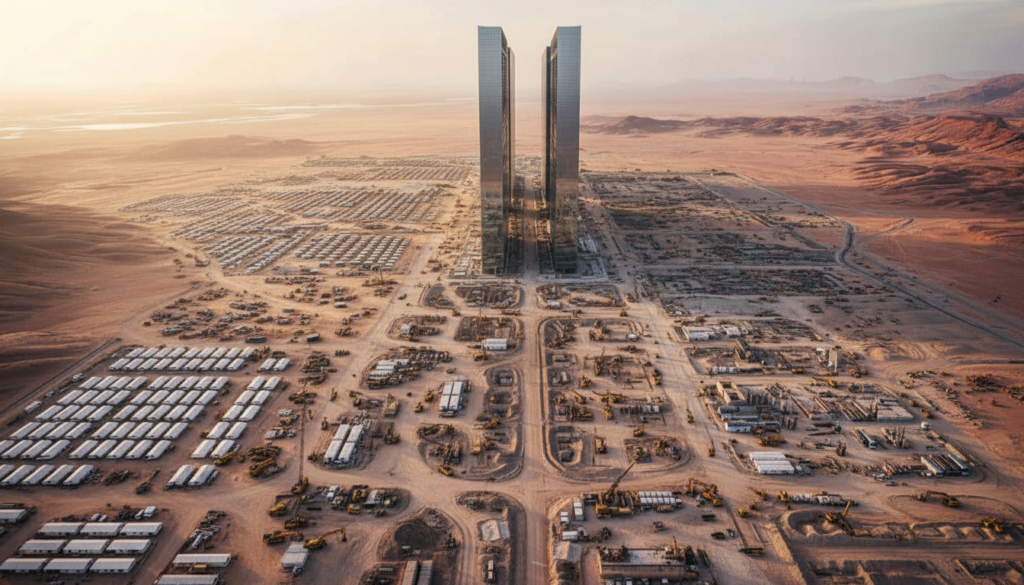
It’s called NEOM down on the ground. It’s a $2 trillion megacity project that promises flying taxis, robot dinosaurs, and a mirrored city in the sand. The dream looks very different from space.
The desert is honest.

What satellite pictures really show about Saudi Arabia’s megacity in the desert
When you look at the latest high-resolution images on Google Earth or Sentinel Hub, the idea of a perfect futuristic city quickly fades. You can start to see the raw bones of a huge construction site that stretches for hundreds of kilometres across a dry plateau, like an opened-up blueprint.
There are pale tracks where big trucks have driven over ground that hasn’t been disturbed. Huge cut-and-fill scars cut into the sides of hills. Lines of prefab homes appear, arranged with mathematical precision, and their white roofs are baking in the 45°C heat. It looks more like a mining boomtown from above than a city of the future.
One of the most interesting things about recent satellite images is the line of “The Line” itself, which is the famous 170-kilometer mirrored city that Saudi crown prince Mohammed bin Salman promised. You can see a trench that goes on for tens of kilometres, and its straight lines don’t fit with the wild, folded geology of the area.
Grey smudges show where large staging areas are, like cement batching plants, material storage, and equipment yards. New roads from the Red Sea coast cut through wadis that used to be home to flash floods and goat herders.
When you zoom in more, the difference between marketing renders and the real world becomes very clear. Those shiny videos show glass walls that reflect clouds, green terraces, and sleek city canyons that glow at sunset. The satellite version shows dust, logistics yards, and desert horizons that are broken up.
That difference tells a bigger story. What we’re really seeing isn’t a finished vision; it’s a huge gamble on time, money, and political will. You can see how far that bet has come and how far it still has to go from above.
The hidden cost to people and the environment behind the mega-vision
If you look at the satellite images over a few years, you can see another pattern: things that used to be there are slowly disappearing. In one frame, small groups of traditional houses disappear, and in the next, they reappear. Wider, straighter highways have taken the place of dirt roads that used to connect small towns.
Human rights groups have written about how members of the Huwaitat tribe were forced to leave their ancestral lands to make way for NEOM. You can’t see the arrests or the protests from the sky. You see nothing. Big, geometric construction zones now cover up small, uneven marks that life used to leave on the ground.
The story of people is also told in the huge workers’ camps that look like white Lego bricks in the desert. You can see more than ten thousand units on some satellite images, arranged in tight, almost military formations.
Each rectangle is a temporary home for a worker who was brought in from somewhere else, usually South Asia or another part of the Middle East, to build a city they may never live in. The size of these camps, which can grow and shrink or move, gives a quiet hint about who is really on the front line of this $2 trillion dream.
Satellite images also suggest another reality: the environmental footprint. You see new dams changing the shape of wadis to stop rare floods in the desert. You can see cleared strips for power lines, bright blocks of early solar farms, and newly graded coastal areas ready for resorts.

The ad sells NEOM as a “laboratory for the future” that is net-zero and good for nature. What you can see from space so far is an industrial-scale change to a fragile landscape. *Any big project like this costs a lot of money, and the desert is paying a lot of it.
How to look at these pictures without getting caught up in the hype
You don’t have to be a geospatial analyst to see the difference between the promise and the reality. The time-slider on tools like Google Earth Pro is a simple, useful way to cut through the hype. Choose a specific spot along the planned route of The Line, then jump ahead a year at a time.
You’ll be able to tell how fast and how slow things move. Years of little change, then suddenly a lot of new roads, earthworks, and camps. That rhythm tells you more about how NEOM is really moving forward than any well-edited drone video on social media.
Many of us skip over megaproject headlines because they seem like marketing for science fiction. And to be honest, that’s understandable. These announcements about cities of the future often sound like they were made in a boardroom PowerPoint, not in a place where sand hurts your eyes and concrete dust gets into your lungs.
The danger is that we either believe every promise or write the whole thing off as a fantasy. Both reactions miss the more subtle truth in the satellite layers: some parts of this vision are already very real, while others are much farther away than the press releases say.
One researcher who works with remote sensing told me, “Satellite images don’t care about PR.” “They only show what’s on the ground.” The pixels won’t act like the mirrored skyscrapers are there if they aren’t.
Compare the views before and after. Look at the same coordinates in 2016, 2019, 2022, and the most recent year.
Scan for road networks. New highways and service roads are often the first sign that a project is moving from talk to action.
Find support sites—quarries, storage yards, and worker camps show how busy construction really is.
Keep an eye on the coast. Any change in natural shorelines is a sign that tourism and port infrastructure are growing.
Pay attention to what goes away. Villages or farms that disappear can tell you just as much as new developments that shine.
What these desert pixels tell us about the cities of the future
When you zoom out from the trenches and camps, NEOM becomes less about Saudi Arabia and more about all of us. It shows how far governments are willing to go to change the land, move people, and spend a lot of money on projects that mean a lot to them.
You might want to cheer for the tech-utopian dream or call it pure authoritarian vanity. Most of the time, reality is somewhere in the middle. Let’s be honest: no one really knows if this megacity will ever be as big as the original pitch.
The satellite images already show that the time of making promises that can’t be checked is over. You can’t just show people a picture of a 500-meter-high mirrored wall-city and hope they forget to look again in five years. Anyone with an internet connection can follow the scars in the desert and ask, “Is this really what we wanted, and at what cost?”
We’ve all been there, when the dream of a project hits the spreadsheet, the dust, the noise, and the people who are involved.
You might want to open a satellite map next to the headline the next time you see NEOM trend on your feed. It could be about flying taxis, beach clubs or that never-ending shimmering Line. Allow the pixels in the desert to argue with the ads. A picture of our future cities is slowly coming into focus somewhere between the two. It’s messier, darker, and more human than the renderings show.
| Key point | Detail | Value for the reader |
|---|---|---|
| Satellite images cut through PR | Public tools show trenches, worker camps, and gradual progress on NEOM | Gives you a reality check on what’s actually being built |
| There is a hidden human and environmental cost | Displacement, labor camps, and landscape scars appear clearly from orbit | Helps you read beyond the glossy “future city” narrative |
| You can track megaprojects yourself | Using time-sliders, coordinates, and visual cues to compare changes over years | Empowers you to investigate big promises without relying only on official claims |